Why not start off 2019 with some pictures!….. from 2018
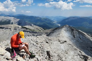
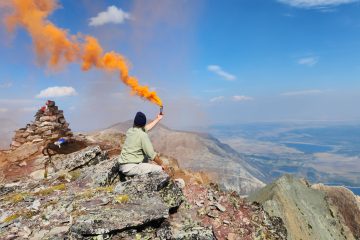
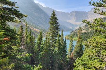
Mount Bryant can be seen in the far distance. The sign in the foreground is a memorial for an airplane crash that occurred nearby. “On August 14, 1941 An Avro Anson Training aircraft from No. 3 service training school Calgary crashed on Mount McDougall about 10Km West of this site. The lives of flying officer L.M. Sutherland – Brown and leading aircraftman F.W. Greenfield were lost. Leading aircraftsman A.M.R. McGruther was injured but survived the accident. Many lives were lost during the period of the British Commonwealth air training plan 1939 to 1945 as aircrew were being trained in Canada for overseas service. To their fond memory this plaque is dedicated.”Moving on from the viewpoint with the plaque to the approach parking area. Scuba Steve (The car), Trusty Rusty (The bike), Mount Bryant (The Mountain).I had heard the approach to mount Bryant was long and tedious. The trail looked perfect for a bike approach to speed things up. Rather than take the time to determine if bikes are permitted on this trail or not, lets just say I walked it.Damage from the 2013 floods ruins the easy going trail further up the valley. Hypothetically speaking however, if you had a full suspension mountain bike, you could keep riding.At this yellow sign, you hang a right. Otherwise, you will end up at Mount Howard.After turning right at the yellow sign and heading up the dry tributary, the going gets a bit too rough to bike anymore…. If I was riding a bike, I would stash it here.The guidebooks are pretty clear, there are two routes to the base of Mount Bryant: 1) steep and short or 2) longer but not as steep. I had long ago decided that short and steep was preferable (cause I’m lazy). The guidebook says to watch for a cairn (pile of rocks) and a steep path leading up from the creek on the left. I looked everywhere for this trail and cairn but couldn’t find it. So here I am, hiking on the long but not as steep trail. It was only on my return down the mountain that I discovered why I couldn’t find the steep trail, more on that later.Eventually, the longer but not as steep trail emerges into a very nice valley. The trail I am following is heading for Bryant Lake, which is at the base of the climb up mount Bryant. I arrive at the shores of Bryant Lake. I imagine in the summer this would be a fantastic location to spend a day by a lake. It’s far too cold and windy for that on this day, besides, there is a mountain to climb! Onward.Despite looking like big cliffs, they are easily navigated through and the ascent is straight forward. It would also appear that some people simply travel far to climbers left around the cliffs. I decide the extra distance isn’t worth the effort.Bryant Lake starts to get smaller as I head toward the summit.A short ridge walk to the summit.Traditional Summit Selfie!!Views from the top aren’t too bad.Mount McDougall, mentioned earlier about the plane crash is over there somewhere. Banded peak makes an appearance on the left hand side.I’m told you can make a loop by following the east ridge seen in this picture back out but given the snowy conditions I decide to return the same way I came. In the distance Moose Mountain is on the left, Prairie Mountain on the right. It’s cold and windy up here, time to bail out!You may recall I mentioned my complete failure to find the short steep route mentioned in the guidebook? On my descent I found it and followed it back to the creek with great curiosity as to how I managed to miss it. Although this picture isn’t clear, there was a recent landslide near the creek that took out the start of the trail and the cairn, making the trail very difficult to find without previous knowledge or using GPS (which I typically don’t use).The remainder of the return journey was long and tedious. I would say boring had it not been for the black bear I came across while not riding my bike out. Yelling “Hey Bear” prompted the bear to run away from me as fast as possible. Unfortunately, self preservation means I didn’t have the opportunity to take a picture of the bear.


0 Comments