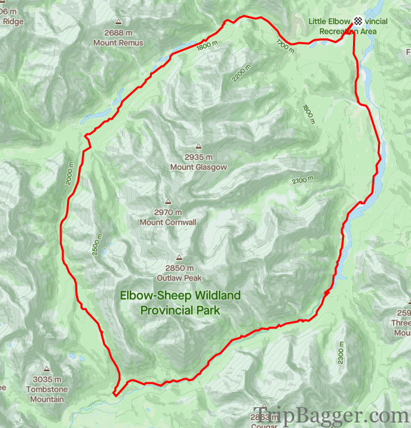
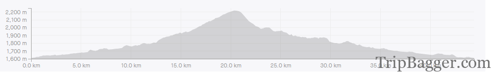
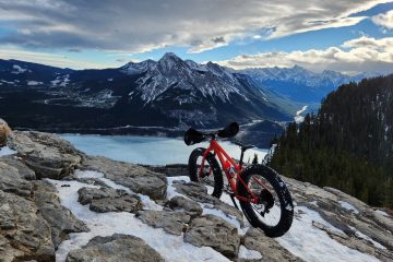
The loop starts at the little Elbow parking lot. From there, head toward the campground. As soon as you pass this registration building you have to make a choice, clockwise or counterclockwise loop.Today, I am going counterclockwise which means riding through the campground first. This time of year, the campground is closed and empty. Once you pass through the campground you will now be on the Little Elbow trail. Side note: If you are a fan of clockwise – Hang a left on to the Harold Chapman bridge not long after the camp registration booth.First stop along the way is the Little Elbow bridge. This bridge was completely destroyed in the floods of 2013 but has since been rebuilt. If you look downstream, you may be able to see the twisted steel remains of the old bridge. The last time I was here, I had to wade across the stream. Having a bridge is nice, my feet are dry!Right after the bridge is the first big hill to climb. You know you have reached the top of the first hill when Mount Remus comes into view. More on Mount Remus here: https://www.tripbagger.com/2015/08/12/shawn-bags-mount-remus-kananaskis/Although most of the trail is in the trees, there are some great views along the way. This bench is at the 10.5Km mark from the parking lot.Just a bit further down the road at the 12Km mark is the Mount Romulus Backcountry campground. This is the turn off if you are heading up Mount Romulus (link below). I also suspect this campground is why they still maintain this gravel road, so they can easily get in to supply the camp ground.The trail does cross a couple avalanche paths so if you are out on the trail in the spring or winter be avalanche aware.After climbing for what felt like forever, the trail started to head back down. I assumed this was the high point of the trail, and you know what that means….Summit Selfie!!Unfortunately, shortly after the trail started going uphill again. Premature summit selfie.Eventually, I arrived at the true high point for the loop. Maybe next time I’ll do some homework first, but probably not.Summit Selfie! For real this time!Leaving the summit, it is all downhill from here, well, for the most part. There are a couple junctions on the return journey. Fortunately, the area is very well signed and marked. You’d have to work pretty hard to mess it up. On the return part of the loop, Cougar Mountain comes into View. You can read more about summiting Cougar here: https://www.tripbagger.com/2021/09/30/shawn-bags-cougar-mountain-kananaskis/ Not much further ahead, at the 28.5Km mark is the turn off for Banded Peak.All but one of the bridges on this loop were destroyed in the 2013 floods. They have since all been replaced with new bridges and in many cases moved up to higher ground to hopefully survive the next big flood. Interesting note, these bridges are not made of steel like their predecessors but are a composite material. I imagine that makes it more affordable to move into remote locations like this. The next bridge (not pictured) is at the 32Km mark.On the home stretch now, “only” 11Km to go. The remainder of the ride out is pretty flat. You may be wondering if you should do the loop clockwise or counterclockwise. Either way, the elevation gain is the same. I’d guess clockwise might have some steeper hills but don’t know for sure. Guess I’ll have to come back and try the other way around.The Herald Chapman bridge is a site for sore legs. It means you are pretty much done, and it is just a short roll back to the parking lot for a well-deserved beverage.


1 Comment
Shawn Bags Cougar Mountain – Kananaskis – Trip Bagger · January 22, 2022 at 8:38 pm
[…] done in about 1 hour at a comfortable pace. For more info on the Elbow loop bike ride click here: https://www.tripbagger.com/2021/10/09/shawn-bags-the-little-elbow-big-elbow-loop-kananaskis/ All of the bridges on the approach trail have been replaced since the 2013 floods. Here you can […]