2019 Update: Thanks to a tip from Erin, note that Stony Trail is closed from April 15th to June 15th.
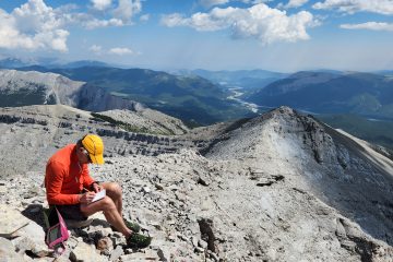
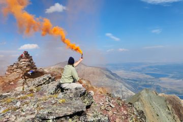
There are two ways to get to Mary Barclay’s Mountain: 1) Cross a river or 2) Ride a bike. I’m always looking for an excuse to take the sui-cycle for a rip so bike ride it is!And away we go! It is very roughly about 6-7Km of biking to the bottom of the mountain.As I approach this base of the mountain I am on the look out for the route. If you look carefully in the bottom left, you can see a Cairn. What is a cairn you may ask? It is a pile of rocks that helps guide you. They are typically found on more popular routes or trails where the route isn’t very obvious.Although there was a cairn marking the way, the trail quickly disappears and you just have to find the best way through the trees.As I gain elevation out of the trees you can see the alternate route to the mountain. It would be to walk down the gravel flats and cross the river. As I mentioned, I took my bike and rode around instead, longer but with dry feet.On the way up I come across another cairn suggesting I am still on-route. Good news!Further up the mountain I came across this bird. I have no idea what kind of bird it is (anybody know?) but do know that he was angry I was invading his space. I changed my route to give him as much room as possible.I took a good look at this dried up creek bed for obstacles as my plan is to use it for my descent rather than going back down the way I came up.Nearing the summit. In the distance is the narrow shark fin looking section. That section will be the crux of the trip.Looking back down the narrow fin.And onto the Summit!Traditional Summit Selfie!The views from up here are pretty good! That is highway 40 heading down the valley.So who was this Mary Barclay the mountain was named after? She was a famous British actor that immigrated to Canada sometime after war. Although she was on Broadway in New York, in her more famous Canadian appearance she was a prostitute in the play Tit-Coq (Little Rooster).Once the captain pose makes an appearance, it’s time to head down!A look back at the shark fin rock summit (and crux). I descended down the backside (left side) and then took the creek out. The right hand side was the route up.
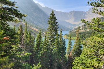
A walk down the rubble creek back to my bike for the ride out. All in all, a good day out.
This is really interesting, You’re a very skilled blogger. I’ve joined your rss feed and look forward to seeking more of your excellent post. Also, I have shared your web site in my social networks!
Cat Erin
· May 30, 2019 at 6:12 pm
I was researching this trip for my group, and on the Gemtrek map of the area there is a note indicating that the Stony Trail is closed from April 15th to June 15th.
Shawn
· June 1, 2019 at 2:47 am
Hi Erin, I checked with Alberta Parks and you are correct. There is now an annual closer on the stony trail path. Bummer. When I have a second I’ll add a warning to this post. Thanks for the heads up!


3 Comments
firtukloimutrzas · April 8, 2019 at 7:14 pm
This is really interesting, You’re a very skilled blogger. I’ve joined your rss feed and look forward to seeking more of your excellent post. Also, I have shared your web site in my social networks!
Cat Erin · May 30, 2019 at 6:12 pm
I was researching this trip for my group, and on the Gemtrek map of the area there is a note indicating that the Stony Trail is closed from April 15th to June 15th.
Shawn · June 1, 2019 at 2:47 am
Hi Erin, I checked with Alberta Parks and you are correct. There is now an annual closer on the stony trail path. Bummer. When I have a second I’ll add a warning to this post. Thanks for the heads up!