An immensely popular trail that is a wee bit quieter in the winter.
Quick Stats
Distance: ~8.0km round trip
Height Gain: ~720m
Round Trip Time: 1h43m
Kane Rating: Easy
Resources: Scrambles in the Canadian Rockies
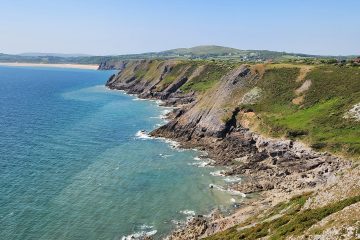
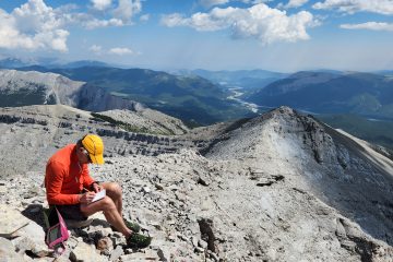
It has likely been over 20 years since I last summited Ha Ling peak. A lot has changed since then, even the name of this peak. More on that later.Don’t let the popularity of this trail lull you into a sense of security. It does travel through some serious avalanche terrain in the winter. Before heading off I would ask: – Have you checked the avalanche conditions website? – Do you have the training and skills to evaluate snow conditions? – Do you have the equipment and skills to self-rescue if an avalanche occurs? – Do you feel comfortable traveling in avalanche terrain given the current conditions? If you do not feel comfortable or have the skills and experience, there are so many other safer options for a winter hike. If you answered yes to all the above, away you go. You will have to work pretty hard to get off route on this trail.The bottom half of the trail is a nice wide trail through the forest. In 2018, the trail was closed for rehabilitation. Essentially, there were so many visitors that the area was being destroyed. The new trail has a more robust surface, rock steps in many places and these chains to keep you on the trail and prevent you from ruining the surrounding area. It took over a year to complete the repair work on the trail.Even down in the forest, the trail crosses an avalanche run out. Given the popularity of the trail, it is possible somebody above you may trigger a slide. Just because you see footprints, doesn’t mean it is safe.As you gain altitude the views start to improve. When they did the trail restoration, they even added some designated viewpoints. Like this one with a safety chain to stop you from plummeting down to whitemans gap.Just before you leave tree line the gradient gets a bit steeper. In these places they have installed steps to help prevent erosion. You can just make out a guy in an orange jacket. He is a certified Canadian Mountain guide. A couple people hired him to guide them up the trail. Great idea if you do not feel comfortable making your own assessment of the snow. Canadian mountain guides are some of the best in the world!This is where the avalanche risk becomes a bit more serious. Why did I feel it was safe to carry on? It had been a particularly warm December with very little snow (less risk). The area above was mostly blown free of snow (less risk). On the flip side, those same winds can create a wind slab situation; something to be aware of. The avalanche risk was also rated as low for this area by Avalanche Canada. I decided the risk was low enough for my comfort level but you need to make your own assessment.Out of the trees and up toward the col between Ha Ling peak and miner’s peak. There are more of the wooden stairs on the steeper sections.The official trail ends at the col. You can however carry on up to the summit of Ha Ling if you feel comfortable doing so. It is important to have some kind of traction aid to prevent you from slipping and falling. I like micro spikes myself, but I did see a couple people using crampons as well. Typical Terrain on the final approach to the summit. I wonder what the sign is all about near the top?This is very true. The other side of Ha Ling is home to the longest bolted sport climbing route in North America (as many as 21 pitches of bolted climbing).Looking down the Bow valley toward Banff. This is a very unusual view…. No other people on the summit of Ha Ling.Looking the other way, I am the only person up here. That doesn’t happen very often. Mount Lawrence Grassi and Miners peak keep me company.Traditional Summit Selfie!The mountain casts a shadow over the town of Canmore. I almost forgot, what about the name change?The old folk lore tale is that a cook from Canmore made a bet he could make it to the summit of this peak and be back in Canmore by noon. He completed the ascent, but his coworkers didn’t believe him. So he went for a second trip up the summit, this time bringing a large flag with him that could be seen from the town below. In honor of his accomplishment, the locals decided they should name the peak after the cook. But gave it the name Chinaman’s peak as the cook was from China. In the 90’s, a local lawyer set about having the name of the peak officially changed to honor the cooks real name: Ha Ling. Our friend Ha Ling could have got back to Canmore even faster if he took a paraglider like this guy did.As the sun sets, it is time to get down before it gets too dark. Fortunately, it is a pretty quick short trail out.


1 Comment
Ted Lawrence · April 3, 2022 at 9:17 pm
Very nice!