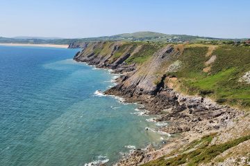
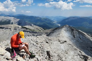
This highway is closed in the winter, and I have used the closed road many times for riding my bike. As you crest the largest hill on the road, you see the North summit of Forgetmenot. Many times, I have said to myself, I should check it out. Today is that day. You can get to Forgetmenot by either fording the Elbow River or taking this bridge. Since it was spring, the river was flowing fairly fast, so I took the bridge. This does add about 2Km total to the trip but beats getting swept away in an icy river. You could also take a bike for the first portion if the extra distance worries you. After crossing the Bridge, the initial objective comes into view (or at least the first small part of it). Up the treed slope and then to the right across the ridge. While following the main branch of the Elbow river toward the East, you must cross a small tributary. Although I believe later in the season you can rock hope across it, I took my shoes off and wadded it. Not long after the crossing is the turn off to head up Forgetmentot. Note the Cairn on the right. On the way up, I passed the dead tree with rocks on it that is mentioned in a few trip reports. You can see the highway in the distance I took the first picture from earlier. As the steep grind up the ridge starts to ease off, the North summit comes into View. Most people are content with the North summit, but I decide I and to visit the North, named middle summit and the South summit.Normally, this is where people hang a left for the closer North summit. I decide I’ll go for the much further away South summit first then return for the North if I still have fuel in the tank after the long ridge walk.A look at where we are heading along the ridge. The blue arrow is the middle and named summit. The red arrow is the south summit, and the green arrow is the ridge extension. It is going to be a long day!First stop is the middle summit looking back toward where I first started on the ridge. I didn’t realize there was a bird in this picture until I got home.Of course, this calls for a summit selfie! What about the strange name of this mountain? Best I can tell, it is named after the plant forget-me-not. View of the next stop, the south summit from the middle summit. I’ll head to the col on the right and then follow the open ridge to the summit. And finally at the South summit. It has been 11.75Km from the car to this summit. There seems to be some debate as to which summit on this ridge is the highest. I measured 2309m elevation with my highly accurate watch. Interested to see what the North summit is. Since I make the rules, this calls for another summit selfie!Looking back at the ridge I just traversed. The blue arrow is the North summit. My plan is to head out on the ridge and then on to the North summit. The views along the ridge are very good. The famous banded peak makes an appearance on the right. Cougar mountain on the left:https://www.tripbagger.com/2021/09/30/shawn-bags-cougar-mountain-kananaskis/After returning along the long ridge walk the huge Cairn on the North summit comes into view. My watch indicates it is 2235m meaning it is 75 meters shorter than the much further away South summit. I’m sure some may question if the extra 75 meters of height are worth the very long ridge walk. The third and last traditional summit selfie for the day at the North Summit. By this time I had walked just over 20km and still had 6 left to get back to the car. Having run a marathon earlier in the season, 26km seemed like a breeze!Took a moment to enjoy the scenery (and an excuse for a break) one last time from the more popular North summit, then back to the car the same way I came up.


0 Comments