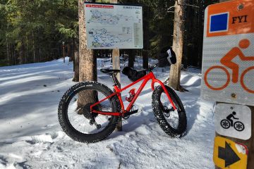
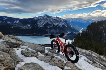
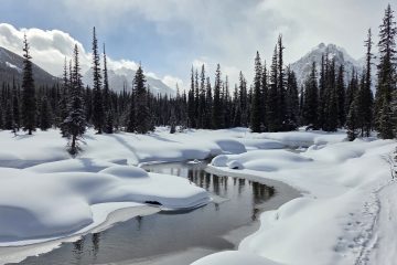
What the hell is the greenway loop?Back in 2009 somebody came up with the idea to create a bike path that goes around the entire city of Calgary. I had heard rumours that after almost 10 years of construction it was nearly finished, close enough that you could complete the loop now.I had also heard rumours that a few people had completed they loop by splitting it up into chunks and doing a chunk each day. For example, the North West quadrant on day one, South West on day two etc…. Not wanting to waste a bunch of time driving to the different sections I decide, why not just do the entire loop in one day? (I am not a smart man)Sian, being a bit more sensible, offered to join me for the first 25Km or so.Here she is, waiting for me as usual while I attempt to take pictures.So what’s the big deal about a little bike ride around the city you may wonder? I should have mentioned, the greenway loop is the longest continuous urban bike path…. In the world! This picture was taken from the NW corner of the path, you can see downtown Calgary in the far distance, giving an idea of the distances involved.For a good portion of the ride, the path parallels Stoney Trail, which is the ring road that also circles the outside of Calgary. The weather looks threatening but I press on.So exactly how long is the longest urban bike path in the world you may be wondering? Officially, it is 138Km long. My ride however, measured at 156.95Km. I decide I am right (I also had to ride from my house to the path which likely added the extra distance).At 25Km Sian gives the thumbs up and bails out. Only 113Km to go!The pathway passes through bowmont park (which has some great mountain biking trails FYI). In the distance you can See Canada Olympic Park and the ski jumps, home to the 88 Olympics, but not the 2026 Olympics.Looking down the bow river valley. This is still in the NW corner of the city.Despite the stormy skies people were still out enjoying summer in Calgary (which is notoriously short).Taken from the west side of the city, downtown again in the distance. These signs are present around the entire loop. The top portion is in the event you have an emergency you can describe to the 911 operator exactly where you are. The signs underneath help you navigate the pathway system (as an aside, there is a sign in the community of Royal Oak that has the arrows pointing the wrong way, that confused me).This is a bike path right? I spent far too long considering if it was possible to ride down the little ramp on these stairs. Maybe next time.Down in the weaselhead area. That warning sign is there because this area used to be used by the military and occasionally people will find old ordinance in the park.Now down in the Southern part of Calgary, Fish Creek Provincial Park. Where they have these weird saggy bridges. I should have counted how many bridges I crossed, there were many.I came across a deer in Fish Creek Park.I also rode through the windows 95 desktop along the way.At the half way point I stopped for lunch. I only took the one break on the entire ride as I had a Birthday Party to attend to that evening and perhaps didn’t allow myself enough time. My weapon of choice for this ride is a Devinci Hatchet.Looking down over Fish Creek Park. The pathway below can be seen in the middle of the picture. Given that this is about the half way point, only 69KM to go! I’m practically home.From Southern Calgary downtown can be seen far off in the distance.Recall I mentioned the pathway is almost complete? This mud flat is supposed to eventually have a bridge over it. I decided the mud looked pretty dry and walked across it. It was only dry on top and I was covered in mud by the end of the crossing.This wetland on the other hand did have a completed bridge. The greenway loop cost 50 million dollars to build and passes through 55 communities.On the east side of the city the parries carry on forever. By now you may be wondering, where is the Traditional summit selfie? Despite having climbed about 1200m of elevation on this trip…. I forgot to take one.Back in the North West I am near the final leg of the journey. There was a strong headwind which slowed things down and the 8 hours of non-stop biking had taken its toll. I was glad to be finished and decided I would never ride this pathway again…. Well maybe just once more.


1 Comment
firtuklo imutrzas · April 5, 2019 at 6:15 pm
I really prize your piece of work, Great post.